| 1. |
This course provides supplemental requirements and information to the following:
- Part six (6), Temporary Traffic Control, of the National Manual of Uniform Traffic Control Devices (MUTCD)
- NYSDOT Transportation Maintenance Safety Manual
- Existing NYSDOT safety bulletins, for NYS Employees,
- Supplement the Construction Program Employee Safety Manual
- NYS Supplement the National Manual of Uniform Traffic Control Devices (MUTCD)
|
|
|
True |
|
|
False |
| 2. |
Right of Entry; Section 30, Paragraph 17, of the Highway Law authorizes NYSDOT personnel and consultant surveyors acting on behalf of NYSDOT the right to "enter upon property for the purpose of making surveys ………" Section 404 of the Eminent Domain Procedure Law repeats this authority. |
|
|
Authorizes |
|
|
Does not authorize |
| 3. |
The Department’s rights-of-entry extend to corporate as well as private property. This right may be exercised if necessary. However, entry upon corporate property offers a greater likelihood of hazards to members of the survey party. There is also the possibility of interfering with costly operations, or compromising the imposed security of a facility. Extra effort should be made to notify managers if there will be entry upon corporate property. |
|
|
This right may be exercised if necessary |
|
|
NYSDOT surveyor is not allowed to enter a corporate property |
| 4. |
Surveys are performed on the irregular surface of the earth, and are then transformed into a plane rectangular coordinate system for ease of use in engineering and surveying computations. In a state as large as New York, ____________ for a consistent, accurate, and documented system so that surveys performed for NYSDOT are related in a standardized system. This requires a well-defined coordinate system and datums, which NGS has developed and NYS has adopted. This coordinate system and datums will provide NYSDOT with a consistent, accurate, and reproducible system, which will protect the interests of the People of the State of New York. |
|
|
There is no need |
|
|
There is a need |
| 5. |
Surveys for NYSDOT shall be connected to the NYS Spatial Reference Network (NYSNet). NYSNet is a network of continuously operating Global Positioning System (GPS), reference stations (CORS) throughout NYS that can be used for differential GPS applications. NYSNet is part of the National Spatial Reference System (NSRS), maintained by the National Geodetic Survey. |
|
|
True |
|
|
False |
| 6. |
NYSPCS is made up of |
|
|
4 zones: West, Central, East and Long Island |
|
|
3 zones: West, Central, and East |
|
|
2 zones: West and East. |
| 7. |
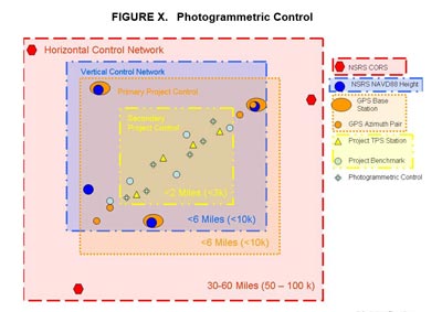
"Primary Project Control" may pre-exist in proximity to a project site. The Regional Land Surveyor __________ prior to conducting a primary project control survey to determine whether pre-existing control shall be used. |
|
|
Shall be consulted |
|
|
Does not have to be consulted |
| 8. |
Monumentation for “primary project control” should be a NGS 3-D rod, disk in massive concrete structure or bedrock, a poured in place concrete monument, or a drive-in type with expanding prongs (e.g., Berntsen FENO). |
|
|
True |
|
|
False |
| 9. |
All primary project horizontal control stations shall be tied to 3 or 4 physical features, depending on the situation. Measure angles and distances, to tie objects, with a total station and record in the data collector. Observations to tie objects are normally recorded as a horizontal angle, slope distance, and zenith angle observation in the data collector. Distances can also be measured with a steel tape and entered into the data collector. The intent is for the ties to be plotted accurately and automatically in the digital graphics file with the rest of the survey information. Horizontal distances from tie objects ______________ in reports, drawings, or computer files, unless otherwise noted. |
|
|
Does not have to appear |
|
|
Should appear |
| 10. |
In Network Design, you need to structure your network design such that closed figures (loops) are created from baselines observed in two or more sessions. Each loop shall have at least one baseline in common with another loop. All new stations shall be included in a loop of not more than 10 baselines and a loop length of |
|
|
Less than 60 miles. |
|
|
More than 60 miles |
|
|
Less than 100 miles |
| 11. |
A GPS Plan for the Primary Project Control shall be submitted to the Regional Land Surveyor for review and approval, prior to beginning of any fieldwork. Which one of the following should the GPS Plan shall include:
- A network diagram showing in dependent baselines by sessions (indicates sessions by either (a) color, (b) line symbology, or (c) label/number the lines).
- A summary of network statistics (seeSection8.7.2.1).
- A session schedule.
|
|
|
1 and 2 |
|
|
1 and 3 |
|
|
1,2, and 3 |
| 12. |
In 8.4.2.2 Trigonometric Leveling, The total station used for trigonometric leveling should be a one-second least-reading instrument. The total station used should have a minimum DIN accuracy of two seconds (angle) and 2mm +2ppm (distance).
Account for the correct prism offset in all distance measurements. Always use a target device with a retro-flector prism. The reflector alone does not make an adequate vertical target. The target/reflectors shall be tripod mounted. Limit sight distances to about ___________ to minimize the impact of small pointing errors. Longer sight distances may require additional pointings, resulting in a larger sample from which to derive a mean vertical angle.
|
|
|
1000 ft. ( 300 meters) |
|
|
2000 ft. ( 600 meters) |
|
|
500 ft ( 150 meters) |
| 13. |
When the term "secondary project control" is used in this manual it refers to the control traverses, baselines and level lines occurring through the project site. The purpose is to control the engineering and real property acquisition work required for a project. Points established under these standards and procedures are generally within the work limits of the project and are assumed to be expendable but recoverable. |
|
|
True |
|
|
False |
| 14. |
When the term photogrammetric control is used in this manual it refers to the ground control targets or photo identifiable points occurring within the area of a project. The photo control can be selected before (pre-marking, e.g. targets), or after (post-marking, e.g. photo-identifiable points) the aerial photography flight. Whenever possible, targets should be used. Photo control is used to control the photogrammetric mapping and DTMs required for a project. Points established under these standards and procedures are generally within the work limits of the project and are assumed to be expendable. Photogrammetric control traverses, level runs, and GPS networks should
 |
|
|
begin and end on at least secondary project control stations. |
|
|
begin and end on Vertical Control Network. |
| 15. |
Photogrammetric control surveys can be conducted before or after aerial photography flights. Photo control surveys conducted before flying should include the horizontal and/or vertical coordinates of targeted points (HPs & VPs). Aerial photo targets shall be placed in the field, to be used as photogrammetric control points. The targets shall be placed in accordance with the NYSDOT targeting diagram and "Targeting Guidelines". A hand- held GPS receiver shall be used to determine the approximate coordinates of the actual target locations, and a text file with the approximate coordinates shall be submitted. |
|
|
True |
|
|
False |
| 16. |
Surveyors shall employ dual frequency GPS receivers. Not less than ____________ receivers shall be employed during an observation session, at least one reference base station receiver and one rover receiver. When using the NYSNet RTN, using just one rover receiver meets this requirement. Fixed height tripods should be used at GPS base stations. Fixed height tripods or a bipod/GPS pole should be used at target locations. |
|
|
Two GPS |
|
|
Three GPS |
|
|
Four Gps |
| 17. |
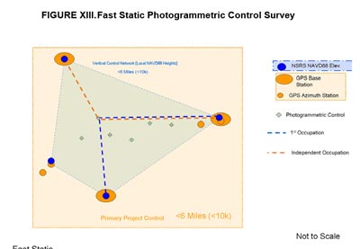
In Fast Static photogrammetric Control survey, at least ______________________________ shall be incorporated into network design (i.e. azimuth pair stations or base stations surveyed to primary project control GPS Base Station Standards).
 |
|
|
three primary horizontal project control stations, being in different quadrants |
|
|
two primary horizontal project control stations, being in different quadrants |
| 18. |
In Terrain date ( topographic) surveys; All mapping, DTM, and geometry features for Terrain Data surveys shall be located directly from secondary project control using a Total Station Positioning System (TPS) and radial surveying techniques, except when alternative survey data collection systems are approved for use by the Department, (see Section 11.2). |
|
|
True |
|
|
False |
| 19. |
In Right of way (ROW) mapping surveys; The objectives of the chapter are |
|
|
to provide Department employees, consultant surveyors, and designers with a standardized format to follow when locating property line and highway boundary field evidence that could be used to determine the locations of property lines and highway boundaries. |
|
|
Which mapping method has the right of way compared to other methods |
| 20. |
There are generally two types of replacement bridges.
- Replacement at the same general location, with traffic being detoured either at or off site.
- Replacement at the same general location, with traffic being maintained at the site using stage construction.
|
|
|
True |
|
|
False |
|
